California Institute of Technology
Guaymas Basin, Gulf of California, México
Project: Mass transport deposit related to transform fault in the Guaymas basin, Gulf of California: Implications for regional tectonic activity
The Guaymas basin, in the central Gulf of California, is a 100 km wide young marginal rift basin characterized by active seafloor spreading. The Guaymas Basin contains tabular intrusions (sills) and a thick package of organic-rich sediments surrounding the spreading center (Lizarralde et al., 2007, 2010). In this work, we identified in the seismic reflection data a significant mass transport deposit (MTD) at the SE Guaymas Basin. The geometry of the MTD in the Guaymas basin contains important information about the evolution of the Guaymas Transform Fault and the Guaymas Basin in the last million years.
Advised by Joann Stock
Collaborators: Daniel Lizarralde (WHOI, USA), Christian Berndt (GEOMAR, Germany), Antonio González-Fernández (CICESE, MEX), Carlos Mortera (UNAM, MEX), Kathleen Marsaglia (CSUN, USA), Arturo Martin (CICESE, MEX), Christian Gallegos (CICESE, MEX)
Methods: Seismic reflection interpretation in Kingdom suite
Data Sets: Multichannel seismic data from Sonne 241 (GEOMAR) and Alpha Helix (CICESE)
Manuscript status: in preparation
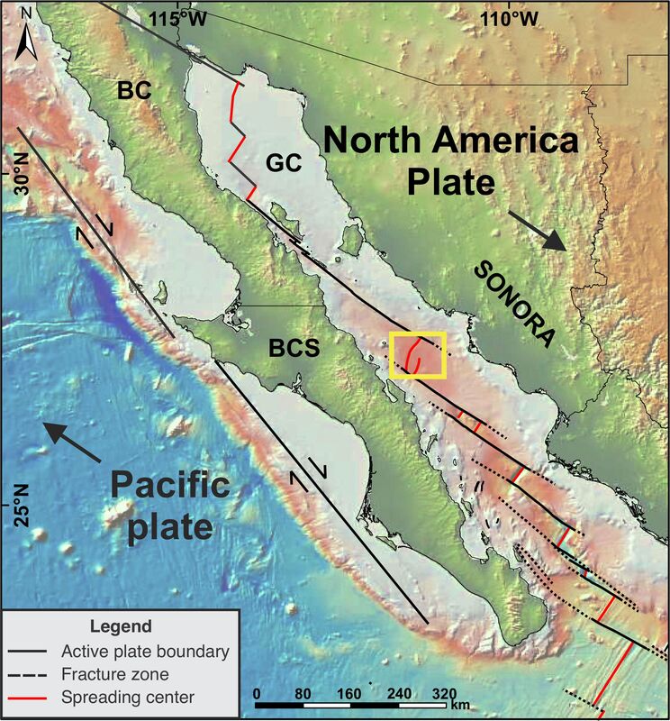
Tectonic setting of the Gulf of California. BC= Baja California; BCS= Baja California Sur; GC= Gulf of California. Base map from GeomapApp.
|
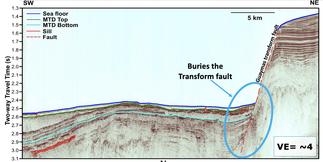
SW-NE section of the Line 116 (Sonne 241) showing the main characteristics of the MTD. Please see the segment of the line 116 shown in the bathymetric map.
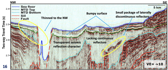
NW-SE section of the Line 1 (Alpha Helix) showing the main characteristics of the MTD. Please see the segment of the line 1 shown in the bathymetric map.
|
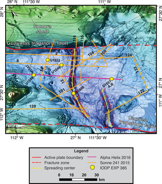 Bathymetric map of the central Guaymas Basin showing the data sets used in this work. Bathymetry provided by D. Lizarralde.
Project: Correlation of ash beds in the Quaternary marine sedimentary well data acquired during IODP Expedition 385 in Guaymas Basin, Gulf of California
In 2019 IODP conducted an interdisciplinary research cruise in the Guaymas basin where they drilled several cores. Within the stratigrapy of the cores some ash beds were found in different depth levels. For this project, I will try to establish the quaternary stratigraphy of the basin based on the ash correlation. The Guaymas basin, in the central Gulf of California, is a 100 km wide young marginal rift basin characterized by active seafloor spreading.
Advised by Joann Stock
Collaborators: Kathleen Marsaglia (CSUN, USA) and Arturo Martin (CICESE, MEX)
Methods: Petrographic, microprobe, and ICPMS analyses of the ash beds
Data Sets: Drilled cores acquired by the IODP EXP 385
Manuscript status: not started, lab work in progress
Project: Geochemical and geochronological analysis of the Isla Tortuga volcano: implications for Quaternary volcanism in the Gulf of California
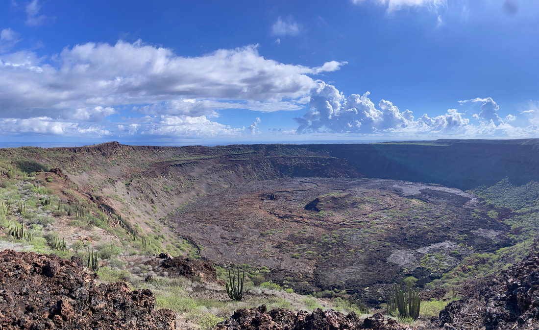
Isla tortuga is located in the Guaymas Basin, Gulf of California, Mexico. This island corresponds to a young volcano and it is part of the volcanism produced by the extensional tectonics in the Gulf of California. The age of this volcano is unknown, so during the fieldwork, we collected samples for geochemical and geochronological. In addition, the IODP EXP 385 drilled cores in the Guaymas Basin and they found ash beds within the stratigraphy of the cores. We think the Isla Tortuga can be the source of part of these ash beds. So, we will compare the geochemical composition of the lavas and pyroclastic flows with the ashes from the Guaymas basin.
Advised by Joann Stock
Collaborators: Brian Hasuback (CSUS, USA), Josh Anadu (Caltech, USA), Eran Funaro (Caltech, USA), and Arturo Martin (CICESE, MEX)
Methods: Petrographic, XRF, microprobe, ICPS, Ar-Ar, analyses
Data Sets: Rocks collected in the field
Manuscript status: not started, lab work in progress
Soda Minette sill, Johnnie Formation, Death Valley, USA
The soda minette sill is a lamprophyre that intrudes the upper Johnnie formation in the Death Valley, USA. It is characterized by a significant hydrothermal alteration and it contains phenocrysts of potassium feldspar, biotite, titanite and quartz. This small intrusion carries ancient zircons that provide information of the overlaid crust and its age helps to constrain the triassic volcanism of the North America Cordillera during the Sonoma orogeny.
Advised by Brian Wernicke
Methods: Petrographic, SEM, XRF, U-Pb and K-Ar analyses
Manuscript status: In preparation
Advised by Brian Wernicke
Methods: Petrographic, SEM, XRF, U-Pb and K-Ar analyses
Manuscript status: In preparation
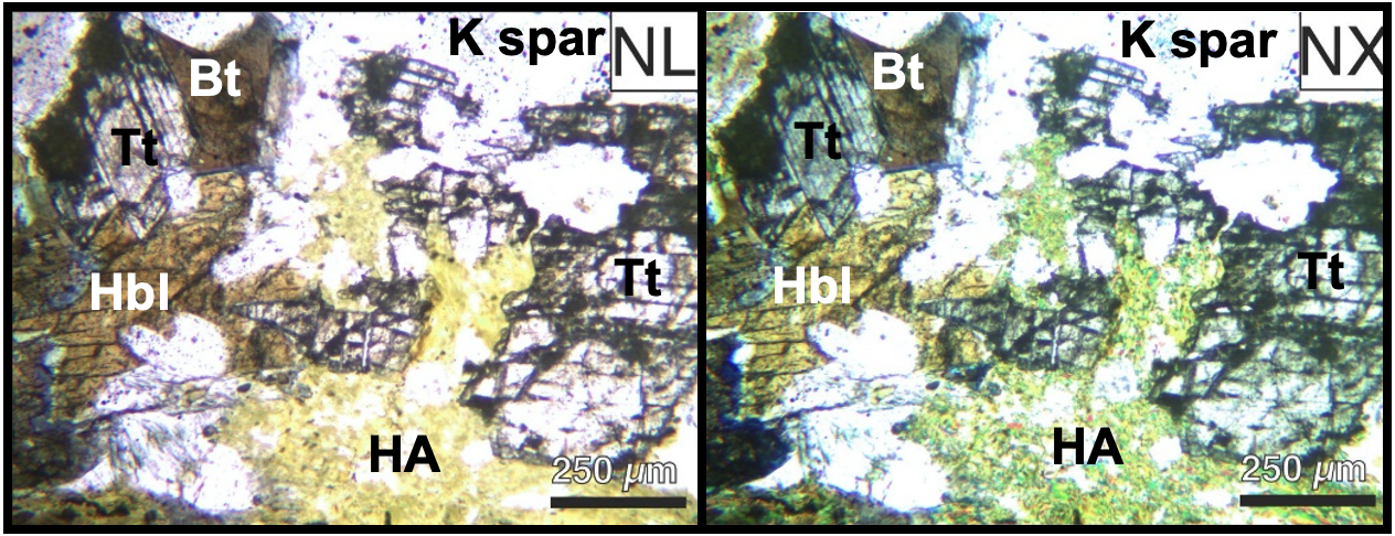
Thin sections of the soda minette sill in natural light (NL) and polarized light (NX)
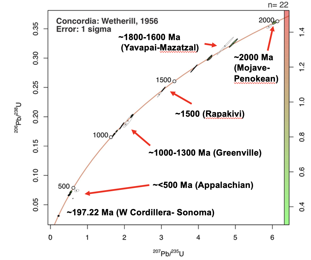
Concordia diagram of the U/Pb data obtained from the zircon ages in the soda minette sill
University of Sonora, México
New insights into the Northern Baja California Microplate reconstruction at
ca. 12 Ma: Petrography, geochemistry, and paleomagnetism of the Ignimbrite
of Hermosillo – Tuff of San Felipe in San Carlos, Sonora, México
The Los Algodones mountain range is located north of the town of San Carlos in Guaymas, Sonora, Mexico. Los Algodones is characterized by an igneous-metamorphic basement of Triassic-late Cretaceous age and two tilted volcanic sequences and dikes of Miocene age. The first volcanic sequence overlies the basement and has lavas of early-middle Miocene with intermediate to mafic composition. Late Miocene lavas represent the second sequence with intermediate to felsic composition, including two ignimbrite deposits. Stratigraphic position, and petrographic, geochemical and paleomagnetic studies of the Los Algodones Ignimbrite (LAI), one of the ignimbrite deposits, establish that this unit is part of the ca. 12 Ma Ignimbrite of Hermosillo - Tuff of San Felipe (IGH - TSF), a widespread stratigraphic marker in NW Mexico. Based on LAI petrologic characterization, this deposit can be correlated with a lithological unit reported at Cataviña, Baja California, Mexico, 430 km away from the study area. This new tectonic point it allows us to propose a new reconstruction of the Baja California microplate to its original position on the North American plate. Paleomagnetic studies confirm a high tilted and a significant vertical axis rotation in the IGH – TSF, which are related to transtension during the evolution of the Proto-Gulf of California oblique rift.
Advised by Jesús Roberto Vidal-Solano and Joann Stock
Methods: Petrographic, XRF, structural and paleomagnetic analyses
Manuscript status: Submitted
Advised by Jesús Roberto Vidal-Solano and Joann Stock
Methods: Petrographic, XRF, structural and paleomagnetic analyses
Manuscript status: Submitted
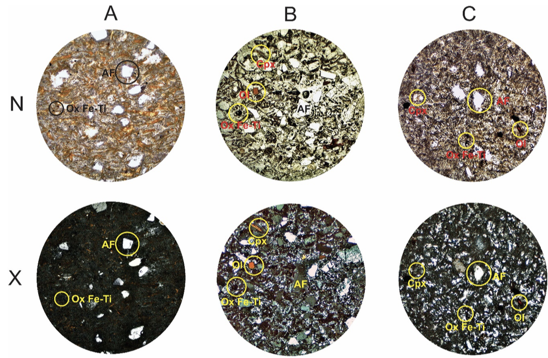
Representative thin sections of the IGH-TSF from San Carlos, Sonora. A) Palagonitized
facies; B) Tuffaceous facies; C) Welded facies. N= Natural light;. X= Polarized light; AF=
Alkali feldspar; Cpx= Clinopyroxene; Ol= Olivine; Ox= Ti-Fe Oxides.
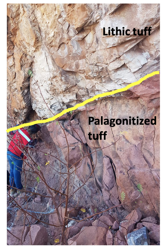
Outcrop of palagonitized facies of IGH-TSF in contact with its lithic facies
|
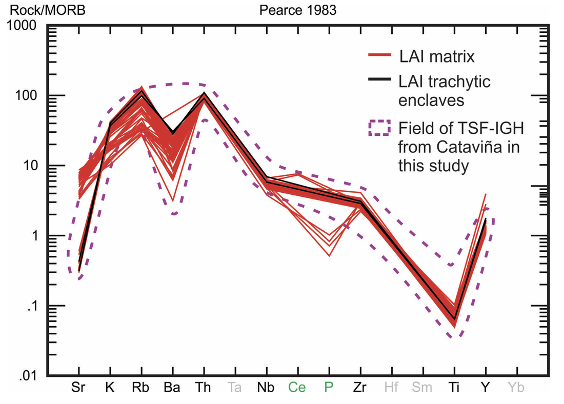
Spider diagram of normalization to MORB (Pearce, 1983) of the IGH-TSF deposits from San Carlos, Sonora, and
some deposits from Cataviña, Baja California.
|
